Location: Canada
Elevation: 5, 959 meters
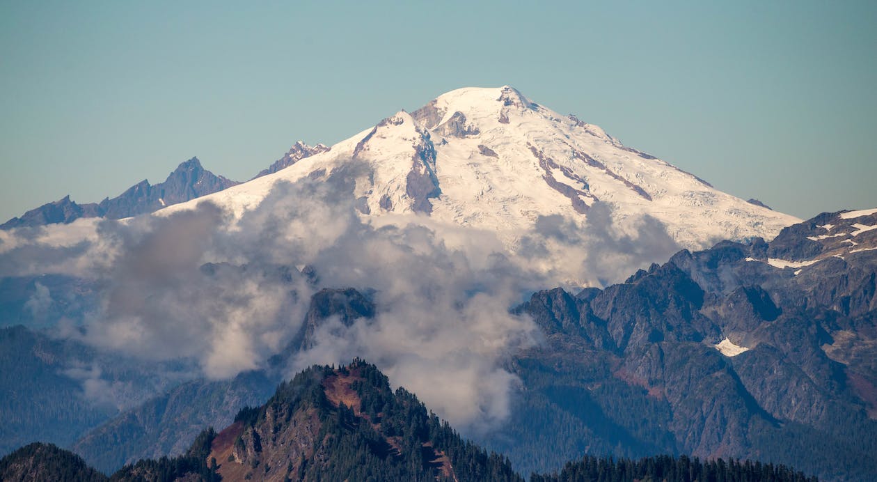
Mount Logan is the highest peak in Canada and the second-highest in North America next to Mount McKinley in Alaska, United States. The mountain belongs to the Saint Elias Mountain Range and is located in Kluane National Park and Reserve. It was named after a Canadian geologist, Sir William Edmond Logan, who founded the Geological Survey of Canada.
Active tectonic uplifting causes Mt. Logan to still rise in height. Logan is notable for having the largest base circumference among non-volcanic mountains on Earth. To put the size in perspective, you could put Mt. Eiger, Mont Blanc, and Mt. Kilimanjaro on top of the plateau summit and still has a few spaces left. It is also the center of an enormous glacial expanse in the continent and one of the world’s most extensive non-polar ice fields.
The areas on and near the mountain have low temperatures. At 5000 meter altitude, the air conditions stay near 0℃ in Summer and reach up to -47℃ during Winter.
The first ascent to the summit was in 1925 through an expedition led by A.H. MacCarthy and H.F. Lambert. It took them 65 days to reach and return from the summit with all trekkers intact. Today, the mountain can be climbed using 13 different routes. The easiest and the most popular way to reach the peak is via the King Trench route, which was also used by MacCarthy and Lambert’s team.
About the King Trench Route trek
Unlike in 1925, modern trekkers can now finish the climb in three weeks. An air taxi has been installed from Kluane Lake to Alaska-Yukon, speeding up the trip. This route also offers long, glacial landscapes perfect for ski touring. Qualifications for prospect climbers include glacial maneuvering, winter camping, crampons, roped glacier travel, and crevasse rescue skills. There are four to five camps to be set up within the week, and baggage can be carried using glacier sleds. Trekkers must prepare themselves for non-step four-mile travel from the high camping grounds to the summit. It will also involve glacial traverse through icefalls, crevasses, 50-degree slopes, and frigid temperatures. The greatest challenge for the climb is not its technical difficulty but surviving the possible extreme weather conditions while carrying heavy supplies for weeks.
When is the best time for the climb
The weather conditions above Mt. Logan is volatile as storms can occur pretty quickly. Therefore, the best time to climb is from late Spring to Early Summer. Generally, May is an excellent month to go as it is significantly drier than June, July, or August.
How long is the hike to Mt. Logan summit
The first day begins with a two-hour shuttle ride to Kluane Lake, where trekkers will be setting up a camp near the airstrip. This day is also dedicated to checking the things needed to carry and inspect whether the gears are functioning correctly. The next day will be the flight to the QuintinoSella Glacier base camp. As some flights are often delayed, some trekkers stay up to four nights at the Kluane Lake. Upon reaching the base camp at about 2700 meter elevation, there will be a six-hour hike along a crevassed section to the entrance of King Trench. This place is considered as Camp 1.
Tomorrow will be the ski ascent to Camp 2, which is the King Col (4000-meter elevation). The route has a lower angle allowing trekkers to pull their supplies easily using a sled. After King Col is Camp 3 at Prospector Col, the section between Camp 2 and Camp 3 is the route’s crux. You will be required to carry the supplies using backpacks. Some places have massive crevasses, and slopes can reach up to 45 degrees. The strategy, therefore, is to approach the course using the “carry high-sleep low” method. This approach is to ascend no more than 600 meters per day to help trekkers acclimatize to higher elevations. From the high camp, trekkers have to wait for the best weather window to attempt the summit.
If everything went as planned, you would be left with a week’s supply of food before continuing the trek. It will take around three to four miles to reach the summit from the high camp. It is not steep terrain, but it sure would test your endurance. Brace yourself for a 10-15 hour journey before conquering Canada’s highest point.
The remaining days will be the descent down the mountain. You will start going back to Prospectors Col and stay the night there. The next day you will descend to Camp 2 or continue as far as possible. If you are lucky upon reaching QuintinoSella Glacier base camp, you can immediately take a ride back to Kluane Lake. If not, you must camp for days near the airstrip.
How much does the hike cost
As this is relatively a long expedition, trekking cost varies from USD 5000 up to USD 7700. Most agencies include guiding services, climbing permits, entrance fees, flight from Haines Junction to the base camp, and all meals and climbing equipment.