Location:Washington
Elevation:2, 703 meters
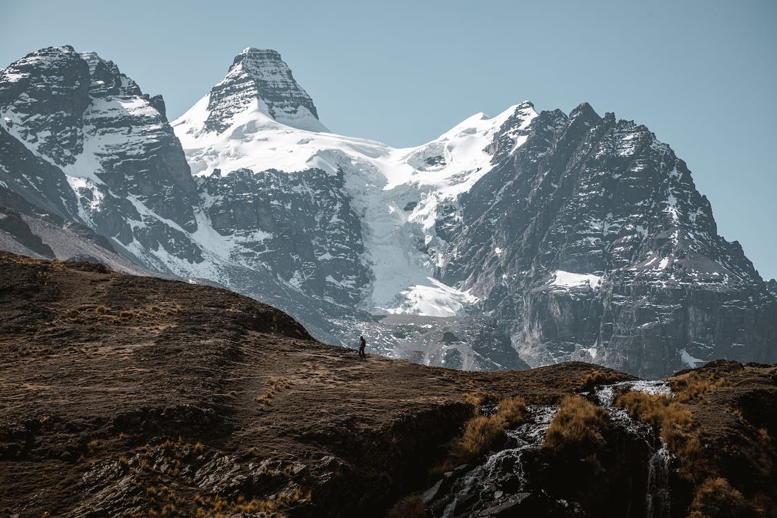
About El Dorado
Standing 2, 703 meters high, Eldorado is one of the highest peaks in Washington situated in the North Cascades National Park, approximately 27 miles east of Concrete. The mountain is skirted by the large continuous non-volcanic ice sheet in the lower 48 states and some glaciers in the vicinity, including Eldorado Glacier and McAllister Glacier.
Eldorado is famous for its knife-edged summit ridge and its incomparable views. The mountain directly approaches El Dorado Glacier, thus offering mountaineers ample time and opportunity to practice glacier trekking skills before reaching the exposed East Ridge that contains steep snow but fantastic climbing exposure.
Geology
Eldorado has simpler geological formations than the other mountains in the Cascades. It only has one primary rock type, the Cretaceous orthogneiss, more specifically biotitegranodiorite. The different rock types, mostly heterogeneous, are only found on the lowest sides. There are only two normal faults: on the west side and the east side.
When is the best time to climb
Like any other mountains, you may choose to climb any time of the year but prepare yourself for the current weather conditions. It would be best to make your visit and climb to Eldorado from June to October. However, some would argue that July and August seem to have the best weather and the perfect time to reach the summit.
Standard Climbing Route
Starting at the trailhead, hike 280 feet or more to the left until you reach a big clearing with a beautiful fallen big tree over. Use the log to cross the river but take extra caution because it is often slippery and may have some ice. Go until you reach the end of the log and get off on the right side to avoid bushes and devils club. However, if you can find another way across the river, you may choose it. Sometimes, the log also washed away.
Routes
- East Ridge
The East Ridge is considered the Standard Route to the mountain’s summit as it has a lesser distance approach, a lesser amount of energy and effort for the climb, and is not technical. But this route requires mountaineers to have glacier climbing experience and proper gear and equipment for crevasses rescue.
The route is excellent for alpine mountaineers as it offers scenic views in the State of Washington. What’s also good about this route is that it can be done almost all year round depending on weather, avalanche danger and whether the Cascade River Road is open all the way to mile marker 20.
- West Arete
Eldorado’s most spectacular looking face is West Arete. This route requires a few days for a climb as it has rocky trails with difficulty reaching up to 5.8. Starting at mile marker 20, the West Arete route goes up much of the standard route. It traverses around Eldorado Glacier and the Triad and goes all the way to the bottom of the mountain’s West Face and descend the East Ridge.
- Eldorado from Seattle
Head north on I-5 until you reach Arlington, where you take a right at exit 208 onto highway 530. The highway briefly takes a left in Arlington downtown on Highway 9, and in a few seconds, you need to turn right back onto Highway 530 east to Darrington. The road generally ends at Darrington, which then you need to take a right onto Highway 20 towards Marblemount. When you get to the city of Marblemount, the highway curves after passing the last gas station, so be sure to head straight to the Cascade River Road. Once you have crossed the bridge, the road takes you all the way to Eldorado’s trailhead, which is at Mile Marker 20.
Regulations
There are no camping fees for Eldorado, and the parking is also free. However, for climbers staying overnight, beyond the roads and campgrounds, the National Park Service requires a permit for free, for wilderness protection purposes. The permit can be obtained at the ranger station in the North Cascades or commonly in Marblemount.
You can check the NPS website for the permits, and keep in mind that crowds often come on Holidays, which affects the chances of acquiring a permit. Make an earlier schedule of the climb to Mt. Eldorado.
The Roush Creek rib at 5 400 feet, welcomes climbers for “open camping” and the Inspiration/Eldorado Glacier apron at 7500 feet, are also designated Wilderness Zones which set restrictions on both the number of parties and the number of persons per party.
Other Regulations:
No pets are allowed for the climb because Eldorado is located in the National Park.
The group size limit is 12
Respect Wildlife and other Climbers
Dispose of Waste Properly
How long is the Climb
Usually, mountaineers finish Eldorado climb in 1-2 days maximum. Most alpinists can even make it in a straightforward journey in a single day. Your start time and wake up time in the mountain affect the length of your journey. But during summer, if you choose to stay the night there, you may leave as late as 6 in the morning. But during winter, when there is fresh snow, and the mountain is wet, it is better to start as early as 3 in the morning.