Peaks upon peaks and glaciers after glaciers add to this largest U.S. national park’s grandeur- Wrangell–St. Elias National Park and Preserve. If you follow any braided stream or river to its source, you will find either a receding, advancing or tidewater glacier. The park is an experience to the Alaskan wildlife and historic mining sites.
You surely will be mesmerized by its vastness, which equals to size as Yellowstone National Park, Yosemite National Park, and Switzerland combined! It rises from the ocean all the way up to 18,008 ft., at 13.2 million acres. A vast portion of the Saint Elias Mountains is included, and most of the United States and Canada’s highest peaks, yet are within 10 miles (16 km) of tidewater, one of the world’s most top reliefs.
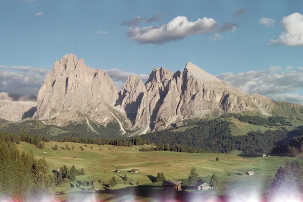
The entire Wrangell range, Saint Elias Mountains’western portion, and the eastern portion of the Chugach Mountains are included in the Wrangell–St. Elias National Park and Preserve. The Nutzotin Mountains, an extension of the Alaska Range, the Granite Range, and the Robinson Mountains, are included in the park’s lesser ranges.
The establishment of Wrangell–St. Elias National Park and Preserve were made possible by the Alaska National Interest Lands Conservation Act in 1980. This American national park is preserved and managed by the National Park Service in south-central Alaska. The International Biosphere Reserve includes the park’s protected areas, which are also part of the UNESCO World Heritage Site-Kluane/Wrangell–St. Elias/Glacier Bay/Tatshenshini-Alsek.
Wrangell–St. Elias boundary is on Canada’s Kluane National Park, and it reserves to the east and approaches Glacier Bay, another American national park to the south. The chief distinction between the park and preserve lands is that sport hunting is prohibited in the park and permitted in the preserve.
There is about 9,078,675 acres (3,674,009 ha) portion of the park and preserve, assigned as the largest single wilderness in the United States.
The uplifting of the mountain ranges that cross the park is due to the plate tectonics movement. And Mount Saint Elias is the park’s extreme high point at 18,008 feet (5,489 m), which is considered the second tallest mountain in both the United States and Canada. The competing forces of volcanism and glaciation shape the park. Among the glacial features are Hubbard Glacier, the longest tidewater glacier in Alaska, Malaspina Glacier, the largest piedmont glacier in North America, and Nabesna Glacier, the world’s longest valley glacier. The park’s exterior is mostly covered by the Bagley Ice field, which includes 60% of the permanently ice-covered terrain in Alaska.
One of the richest deposits of copper in the world is at the center of the park, the town of Kennecott, which was exploited from 1903 to 1938, and the mine buildings and mills that were abandoned comprise a National Historic Landmark District.
Mount Wrangell, is an active volcano. The Wrangell Mountains have a rugged topography, and perennial snow cover is some of the most visually striking of the Alaskan mountains. Meanwhile, Mount Churchill in the St. Elian Range erupted about 2000 years ago and became a White River ash source.
Broad rivers like Chitina River, Chisana River, and the Nabesna River run in a glacial valley between ranges. Nabesna and Chisana River are tributaries to the Copper River.
You can enjoy anytime in the park as it is open all year, but most of its facilities are open from May to September. Some locations may open late at the end of May and close mid-August.
During winter, the main visitor center is open on weekdays. The interior of the park is dominated by long, cold winters by which temperatures can be below freezing within five months. Winter’s usual temperatures at the park can drop to −50 °F (−46 °C) at nighttime, and increases to 5 °F (−15 °C).
Summer lasts only from June to July, where the flowers bloom and insects scatter for pollination. The season can reach a maximum temperature of 80 °F (27 °C). In late summer, there can be drizzles until the temperature cools in August, followed by the first snows fall in September. Coastal areas can have a more temperate climate, and the high mountains retain snow all year.
There is only one Park-Service managed campground in the park; it is the Kendesnii campground on the Nabesna Road. However, there are several private campgrounds and lodgings, and fourteen public-use cabins on the McCarthy and Nabesna roads.
You can reach most of these cabins via plane and a few accessible by the road near the Slana Ranger Station.
It is an ideal place to go trekking and mountain climbing to some of North America’s highest peaks that can be found in this park and preserve. However, climbing these peaks should be taken with extra precaution due to remote and dangerous terrains. Mountain biking during summer is mainly limited to roads due to prevailing boggy conditions.
You can also enjoy sport hunting and trapping but only within the preserve lands. Only residents are allowed of subsistent hunting in both parks and reserves. Hunting activities are managed together by the National Park Service and the Alaska Department of Fish and Game, which issues hunting licenses. And there is no need for any permits for backcountry camping, which is another best activity with families and friends.