Stretches more than a hundred miles along the Blue Ridge Mountains, Virginia, and Shenandoah National Park is a land overflowing with cascading waterfalls, spectacular vistas, fields of wildflowers, and quiet wooded hollows. More than 200,000 acres is protected and is a haven to deer, songbirds, and black bears. It also offers a patchwork quilt of wilderness and pastoral landscapes underpinned by stories from more than 300 years of history.
Shenandoah National park sits between the Shenandoah Valley in the west and the Piedmont region in the east. It is the vastness of wooden hollows and breezy summits, waterfalls and mountain streams, more than 500 miles of hiking trails, and nearly 80,000 acres of designated wilderness—all just 75 miles from Washington, D.C.
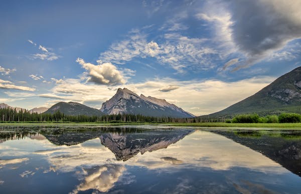
Within the narrow and long park is the Shenandoah River, the broad valley to the west, and the east rolling hills in the Virginia Piedmont. About 79,579 acres or 40% of the park is designated as wilderness and protected as part of the National Wilderness Preservation System. The highest peak is Hawksbill Mountain at 4,051 feet.
The park covers portions of eight counties: At the Skyline Drive west side, from northeast to southwest, Warren, Page, Rockingham, and Augusta counties and on the east side are Rappahannock, Madison, Greene, and Albemarle counties.
History of the Park
The majestic granite peak and sylvan hollows we know now as the Blue Ridge Mountains were formed about billion years ago out of the molten rock that flowed through the earth’s crust, cooled and fractured. Some Native Americans seasonally visited the area to hunt and gather food and collected stones to use in cooking and as weapons.
In the 1700s, second or third-growth forests were logged, and people engaged in extensive grazing, lumbering, and farming. Today, the forests have slowly regrown back.
European hunters and trappers first came 300 years ago, followed by pioneers who led an era of homesteading development. Planting, milling, and mining activities were active in the area. At the time of the US Civil War in the 1860s, cannon blasts echoed through Virginia and the Shenandoah Valley.
Officials of the Virginia state acquired 1,088 privately owned tracts and donated the land to the nation. The park was established in 1935, and the Skyline Drive and the park’s core were completed by the beginning of WWII.
Before the park’s opening, about 465 families were moved from their cabins and resettled outside the proposed park boundaries. A few mountaineers lived out in the park and were hidden in Shenandoah’s vanished settlements’ secluded graveyards.
Almost half of the park was declared by the congress as protected wilderness in 1976. The members of the Civilian Conservation Corps (CCC), a government jobs program created during the Great Depression of the 1930s, built the Shenandoah National Park. Workers built rock walls, trails, overlooks, picnic grounds, campgrounds, and Skyline Drive. They also built more than 340 structures in the park that is now listed in the National Register of Historic Places.
Activities in the Park
1.Hiking
- South District Hikes
The South District of Shenandoah National Park that is more remote makes a good option for hiking opportunities from the easier Blackrock Summit with a rocky talus slope and majestic views to the very strenuous Riprap Trail featuring cascades, and views of Shenandoah’s Wilderness. In the absence of a visitor center, the Loft Mountain Wayside and Campground can offer some services.
- North District Hikes
Visitors choosing the hikes in the North District of Shenandoah National Park will lead to the quiet, historical Fox Hollow Trail, the scenic Overall Run Falls, and Compton Peak, with impressive columnar jointing geological features. Be sure to talk to a ranger at Dickey Ridge Visitor Center while in the area.
- Central District Hikes
Hiking options in the Central District of Shenandoah National Park include scenic waterfalls like Dark Hollow Falls and Whiteoak Canyon, sweeping summits like Stony Man Mountain and Marys Rock, etc. The Central District also includes Big Meadows and Skyland, areas rich with history currently home to lodging, dining, and shopping options.
2.Overall Run Falls
The falls with 93 feet height is the tallest cascade in the park. Visitors can reach to it through trails from Hogback Overlook or Matthews Arm. It’s a tough route featuring an elevation change of 1,291 feet. You can go to a much easier 1.7-mile Traces Trail, which loops through the Matthews Arm Campground woods. For those who want to hike a small portion of the trail but not the entire 2,200 miles from Maine to Georgia, you can hike to the Appalachian Trail that leaps across Skyline Drive near Beahms Gap.
3.Hawksbill Summit
With 4,051 feet height makes this the highest peak in the park. It can be reached from trails that start at two parking spots along Skyline Drive about halfway between Skyland and Big Meadows. The trails are not as tricky as some might expect despite its elevation gain.