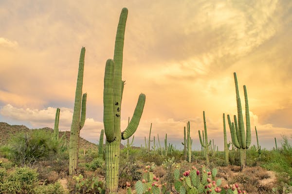
Saguaro is a large species of cactus native to Mexico and Arizona, and California in the United States. The fruits are essential to the Indian diet and as well as its woody skeletons. These cactus also serve as shelter and nesting sites for various bird species. The flowers are an essential source of nectars for pollination insects, bats, and birds.
The giant cactus saguaro is the American West’s universal icon and is found abundant in Tucson, Arizona. It is the universal symbol of the American West and is located only in a small portion of the United States. Abundant species of these plants are protected by Saguaro National Park, to the east and west of Tucson’s modern city, where you can see these vast cacti.
The Saguaro National Park got its name from the cactus. The park is uniquely situated around the 500 square miles that make up Tucson, which is at the Sonoran desert’s heart. It sits under 2,400 feet above sea level. This park is 60 miles north of the U.S. Mexican border and about 100 miles south of the state capital, Phoenix. It is 92 000 acres located at Pima County, southeastern Arizona, and it comprises two separate areas: Tucson Mountain District that is about 10 miles west of the Tucson City and the Rincon Mountain District, about 10 miles east of the city.
These two separate areas have different names for their plants and animals, but the intricate details make both areas praiseworthy. The TMD boasts large stands of saguaro cactus fashioning an awe-inspiring saguaro forest. In contrast, the RMD hosts a beautiful sky island, where you can find bears, cougars, and the ever-elusive coati.
History of the Park
Before the proclamation of the area as a national park, people were living in the land. The earliest residents were the Hohokam, who lived in villages between 200 and 1450 A.D.
Between 1539 and 1540, the Spanish explorers first entered Arizona. There was no non-native settlement of the region near the park until
1692 when San Xavier Mission was founded along the Santa Cruz River. The Spaniards built the Presidio San Agustín del Tucsón in 1775. It was a military fort in what was then part of New Spain to protect against raids by Apaches.
The lands remained relatively free of improvement until the mid-19th century after Arizona had become part of the United States. The passing of the Homestead Act of 1862, came to the railroad system in 1880, and the end of the Apache Wars in 1886, homesteaders and ranchers established themselves in the Tucson and Rincon Mountains. Miners sought silver, copper, and other valuable ores and minerals. There were excessive mining activities in the park that continued intermittently through 1942, while ranching on private in-holdings within the park continued until the mid-1970s.
In 1920, Natural History Society of the University of Arizona members expressed interest in establishing a protected area for saguaro, a cactus species familiar to watchers of silent-movie Westerns. In 1933, the Tucson Citizen publisher and the former United States Postmaster General, who was influential in the Republican Party, Frank
Harris Hitchcock persuaded U.S. President Herbert Hoover to create the area as Saguaro National Monument. And on March 1, 1933, created the monument by proclamation under the Antiquities Act of 1906. Later, President Franklin D. Roosevelt transferred to the National Park Service, the monument’s management, east of Tucson in the Rincon
Mountains. During the Roosevelt administration, between 1936 and 1939, the Civilian Conservation Corps (CCC) built the monument’s Cactus Forest Loop Drive and related infrastructure, and in 1950, the monument’s visitor center was opened.
Activities at the Park
- Camping
Just secure a permit to have a backcountry camping at the park, but there is no available camping for any vehicle and R.V.s. Six designated campgrounds within the Saguaro Wilderness Area are not accessible via vehicle but through a hike. The campsites are Manning Camp, Spud Rock Spring, Happy Valley Saddle, Juniper Basin, Grass Shack, and Douglas Spring.
- Hiking
This extended hike into the rugged wilderness explores terrific opportunities as well as challenges for the adventurous hikers. If you wish for an overnight trip into Saguaro’s wilderness, it can take you from 3,000′ elevation to over 8,000′ in about 15 miles.
Hikes start from any of five trailheads ranging from the easy-to-access Douglas Spring Trailhead at the east end of Speedway Boulevard to the more remote Italian Spring Trailhead with access through Redington Pass on the adjacent Coronado National Forest.
- Signal hill petroglyphs
This is just 0.5 miles round trip to Signal Hill Picnic Area on the Bajada Loop Drive. This short trail lets you walk uphill to a beautiful little viewpoint over the park. You will see the rock art, or petroglyphs, drawn by the Hohokam people over 800 years ago.
- Arizona Sonora desert museum
Although this is not a part of the park, it offers to learn the desert ecosystem, which is also a great place to visit. Functions more of a zoo than a museum, with animal exhibits, an aquarium, and botanical gardens, also have a natural history museum.