

Location:Washington, USA
Elevation:12, 800 feet
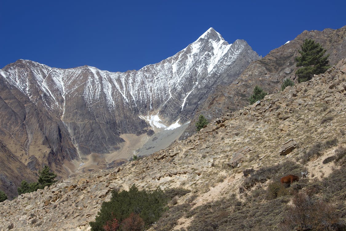
The Liberty Ridge started its popularity in 1996 after it was named one of the “Fifty Classic Climbs” by Steve Roper and Allen Steck. It is considered a premiere guided route on Mt. Rainier. The route is a protruding ridge that splits the Willis and Liberty Walls on the North Face of Mt. Rainier. It is sustained-steep angled, exposed, and committing. Also, it is remote, which makes it the hardest and most dangerous regularly climbed route on Mount Rainier. The route beside the ridge follows an aesthetic line between Liberty Wall and Willis Wall all the way to the Liberty Cap summit.
Liberty Ridge rises out of the Carbon Glacier from 8,000 feet to over 13,000 feet. It hides between Curtis Ridge to the east and Ptarmigan Ridge to the west. The neighboring ridges are much prominent than the Liberty Ridge; that is why it does not define Mount Rainier’s skyline from afar, but it has a magnificent appearance when viewed head-on.
First mountaineers who climbed the area in 1935 were OmeDaiber, Will Borrow, and Arnold Campbell. Daiber even published an account of his climb, which started at the Carbon River and finished in Paradise. They spent almost 52 hours for the ascent and spent the night in the crater rim.
Skill Level and Experience
If you will just look purely at the statistics and the map, it’s easy to underestimate the climb. Still, Liberty Ridge, with a reputation of being tough, is indeed a challenging ascent, especially for climbers who’ve only explored other peaks within the lower 48 states to grasp the magnitude of Mount Rainier’s terrain. This non-standard route with a perilous summit makes an extremely strenuous adventure. Other considerations that add to the difficulty of the ascent are:
- A wide-range of climbing techniques.
Liberty Ridge demands a lot of different techniques (glacier travel, simul-climbing steep snow, short-pitching in alpine terrain, pitched out climbing on the bergschrund, etc.) and the ability to switch from one skill to another quickly.
- Post-holing.
The very thick snow makes the climb to be extra tedious both for the ascent and descent to over 10, 000 vertical feet of terrain
- Navigation on broken glaciers.
A late afternoon climb and crossing the Winthrop and Carbon will be challenging, especially if visibility is at all obscured. Trips can sometimes turn around while gaining the ridge due to the risky and hard-to-find snow bridges essential to cross to ascend the ridge. Down climbing the Emmons-Winthrop route is always changing as the glaciers break apart throughout the season.
- Establishing a camp in steep terrain.
Choosing where to set up your tent or where to camp is also a crucial part of the climb. You need a site free from objective hazards. Also, you need to dig a platform, set up a tent and sleeping gear, and potentially provide a belay or anchor system the whole time. However, darkness, wind, darkness, and steep slopes can cause pieces of an overnight “gear-system” to disappear.
- “Alpine” versus “Siege” tactics.
Which climbing equipment and how much gear to carry up and over the mountain is determined by the objective factors such as the time of the year (season), and weather, and by subjective factors such as fitness level and flexibility with objectives.
Weather
Weather conditions will also be a determining factor whether or not a climb will be smooth or will be more challenging and risky. Since the Liberty Ridge has a committing route, mountaineers must wait for specific weather patterns before launching.
Big storms generally advance with the prevailing winds from the southwest off of the Pacific Ocean. Due to the route’s committing nature, climbers must wait for specific weather patterns before launching.
Good weather includes the following characteristics:
- Pressure system that is stable for the duration of the climb with an extra 24 hours for contingencies
- Below 14, 000 feet freezing levels (less rock and ice fall) and above 6,000 feet (less prone to cold injuries)
- Below 30 mph wind speeds
- Decent visibility (especially important up high and during the descent).
- High confidence (the meteorologist assures the accuracy of the forecast)
Take note: Make a decision ahead of considering the gathered weather forecast across multiple resources. When you are already on the mountain, there will be no signals or warning devices that will announce that the weather is becoming dangerous for the climb. Develop decision points along the route to serve as a reminder to continually re-evaluate the weather during the climb.
Harsh and stormy weather increases the possibility of an accident, but the consequences become direr; neither rescue teams nor helicopters can operate in abysmal weather.
Permits
A permit is required for mountaineers climbing above 10, 000 feet or onto any glaciers. Mount Rainier Climbing Pass and a valid photo ID is presented during the climb registration.
Each climbing party is required to personally complete and submit a climbing registration card to secure a climbing permit. There is no solo travel above high camps or anywhere on glaciers except for the ones with Superintendent’s prior written permission.